We’ve been doing a lot of bike riding these days, training first for the Pan Mass Challenge and now for the Buzzard’s Bay Coalition’s 10th Anniversary Ride.
We thought we might share with you some of our favorite local bike rides. They’re all roughly between 20-30 miles because we’ve found that’s the correct mileage needed in order to indulge in Betty Ann’s black magic sundaes without any negative consequences.
I’ve linked to the routes on Strava so you can download the maps. Rather than rating these rides by level of difficulty, we rate them by access to ice cream — the number of ice cream shops along (or very near) your route. Strava does not give you this critical information. That’s why South Coast Almanac is better.
So That’s Why They Call It Lakeville
(28.6 miles in Wareham, Rochester and Lakeville, download map here)
Ice cream rating: 1
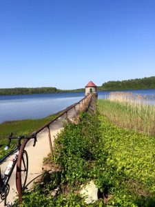
Sometimes I feel like I’m in Vermont ride with its beautiful country roads. Sometimes I feel like I’m in Minnesota (though, to be completely upfront, I’ve never been to Minnesota…I’ve just internalized its license plate motto – 10,000 lakes). I just always feel like I’m away when I’m on this ride. Which is why I love it, even though the ice cream rating is low.
Ice Cream at Robin’s Nest in Rochester. Ice cream novelties at Plumb Corner Market, Rochester.
To (and From) the Lighthouse
(27.7 miles in Mattapoisett and Fairhaven, download map here)
Ice cream rating: 3
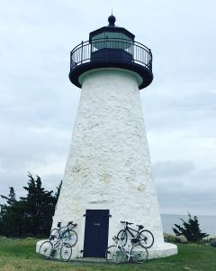
I am enamored of lighthouses so this ride starts and ends at Ned’s Point Lighthouse and the destination is West Island which is itself spectacular. Along the way, you pass through Mattapoisett’s lovely waterfront, the Bluefish home (described here), the Phoenix bike path, and windmills.
Ice cream at Mac’s Soda Bar in Fairhaven, Seaport Ice Cream Slip in Mattapoisett and just off the route at Oxford Creamery, Mattapoisett.
Butler Point & Back
(22 miles in Rochester, Marion and Wareham, download map here)
Ice cream rating: 1
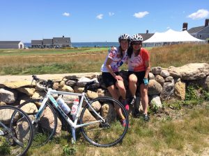
Despite the low ice cream rating, I love this loop. Cranberry bogs, ponds, pristine farms and Buzzards Bay views. As you approach a bend in the road going out to the Kittansett Club, look up at the telephone poles to see the osprey nest and, if you’re lucky, the family will be home. Stop at the farmstand on Point Road, buy a fresh-grown tomato and eat it like an apple.
Ice Cream is available just off the route in downtown Marion at Sea Dips.
Cinderella Ride
(19.3 miles in Onset and Bourne, download map here)
Ice cream rating: 4
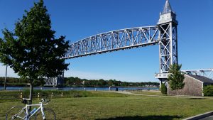
This is a 19 mile ride that is one of my favorites because I can never get enough water views and this one boasts salty views more than three-quarters of the time. Also, it’s flat. Also, look at the ice cream rating.
I call it the Cinderella Ride because on the way out to Scusset, it’s like your fairy godmother has sent you magically off to the ball. You ride feeling like you’re a willowy Olympian atop a high-end titanium bike, effortlessly clocking speeds you’ve never seen before (except downhill). The clock strikes midnight at Scusset when you turn the bike around and face the headwinds. Suddenly, you’re on your sturdy reliable bicycle in your sturdy reliable body. (Still, grateful for both.)
I spend most of the ride back trying to figure out how to game the wind (is there a time of day to avoid it? Is there a time when the wind shifts and you can use it both ways?) Mother Nature just laughs at me and turns up the breeze.
Note: There is a short distance on Cranberry Highway which includes a rotary. If you’d prefer not to tackle that, simply park at the canal and do the 14 mile ride on the bike path.
Ice cream at Nana’s, Guido’s & Stash’s in Onset Village. Novelty ice cream available at Scusset Beach and Andy’s Country Store at Bourne Scenic Campground. Just off the route: Betty Ann’s in Buzzards Bay, home of the wicked black magic sundae
Farms & Sea
(34.5 miles in Dartmouth & Westport, download map here)
Ice cream rating: 3
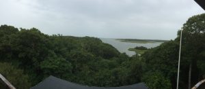
You’ve got everything on this ride: polite drivers, country roads, rock walls, farms, marshes and sea. If I lived closer, this would easily be my go-to ride. Stop at the Lloyd Center to climb up to its observation deck for breathtaking views (detailed in our Only on the South Coast article in the 2016 edition).
Ice Cream at The Bucket at Gulf Hill, Salvadors, Head Town Landing Country Store. Just off the route: Handy Hill Creamery and Wood’s Ice Cream in Westport)
JOIN US
We’ve got a South Coast Almanac team for the Coalition Ride….join us on October 3 if you want to be on the team that wins the costume contest! There’s a variety of distances (100, 75, and 35 mile options) so, even if you’re just starting out, you have more than enough time to get ready. You can learn more about the ride here.
DO YOU LIKE PAPER MAPS?
If you’d like to find your own special rides and if you love paper maps so that you can see the whole picture, rather than just your small screen, check out Bike Friendly Mattapoisett, a map with great biking recommendations brought to you by the Friends of the Mattapoisett Bike Path (available at the Town Wharf General Store), and Rubel’s Eastern Massachusetts Road and Bicycle Map (available at Yesteryear Cyclery in New Bedford).
See you out there!

Love this post….
Thanks Dotty! We hope you bring your bikes to Onset with you and try one of the rides out!
https://www.bing.com/images/search?view=detailV2&ccid=6dlhpFR%2f&id=4110905A3D46A3ADBFF2BCD92149D02EC750EAF8&thid=OIP.6dlhpFR_UGZFP_UZrA19AgHaFj&mediaurl=http%3a%2f%2f4.bp.blogspot.com%2f-JMcAf5gpVqQ%2fVCiQumhmBmI%2fAAAAAAABmNc%2fv0geFZO4BqM%2fs1600%2fIMG_5201.jpg&exph=750&expw=1000&q=east+bay+bike+trail&simid=607995920834105219&selectedIndex=17&qpvt=east+bay+bike+trail&ajaxhist=0 The East Bay Bike Path is a 14.5-mile (23.3 km) paved rail trail in Rhode Island. The path begins at Providence and India Point Park, crosses the Seekonk River via the George Redman Linear Park (opened September 2015) and Washington Bridge and continues southeast to Bristol along the shoreline of Narragansett Bay. There are parking lots in East Providence just before the bridge and it is about a 25 mile round trip to Bristol Harbor. Gorgeous scenery. Places to eat in Bristol. It is really the premier bike path in this area.
The East Bay Bike Path is a 14.5-mile (23.3 km) paved rail trail in Rhode Island. The path begins at Providence and India Point Park, crosses the Seekonk River via the George Redman Linear Park (opened September 2015) and Washington Bridge and continues southeast to Bristol along the shoreline of Narragansett Bay. There are parking lots in East Providence which cuts it to about 25 miles round trip. Developed from an old rail line along the bay. Absolutely the premier bike path in the area. Yes, I have been on all the others shown.
I’m partial to shining sea but neither are on the south coast.
Pingback: 8 Great Things: April on the South Coast - South Coast Almanac
awesome